


La Panne - St Idesbald- La Panne

Michael Heins
User
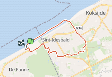

Length
7.1 km

Max alt
14 m

Uphill gradient
31 m
Km-Effort
7.4 km

Min alt
-1 m

Downhill gradient
23 m
Boucle
Yes
Creation date :
2024-01-03 10:38:37.341
Updated on :
2024-01-03 12:28:27.043
1h49
Difficulty : Easy

FREE GPS app for hiking
 SityTrail
IGN / Geographical institutes
SityTrail Plus
The world is yours!
About
Trail Walking of 7.1 km to be discovered at Flanders, West Flanders, De Panne. This trail is proposed by Michael Heins.
Positioning
Country:
Belgium
Region :
Flanders
Department/Province :
West Flanders
Municipality :
De Panne
Location:
De Panne
Start:(Dec)
Start:(UTM)
471749 ; 5661726 (31U) N.
Comments